To the Editor,
Geographic information systems (GIS) are an important epidemiological tool1,2. Applications have been developed based on information and communications technology (ICT) and GIS that associate patient information and the pathologies being studied. In nephrology, there are few studies, such as that by Toubiana et al.³, that have developed a GIS for end-stage kidney disease.
Programmes that integrate GIS and epidemiology require the use of high-resolution satellite or map images at a high financial cost. In addition, converting the addresses of patients into geographic coordinates is an expensive process, since it is carried out manually. Implementing and updating a GIS in epidemiology is a laborious activity. Free applications such as GoogleMaps© are tools for mapping the information, providing high-quality satellite images and allowing an address to be associated with a geographic coordinate4,5. Consequently, we developed a georeferencing tool of patients with glomerular disease from the implementation of a GoogleMaps© API (application programming interface).
METHODOLOGY
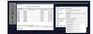
We developed command lines which, at the time when the patient’s address is included, calculate and automatically store the longitude and latitude (Figure 1), information that is required for GoogleMaps© to generate a map.
Map generation
GoogleMaps© API lines of code were modified, incorporating a sentence in PHP code to calculate the size of the screen used for display. We subsequently modified the command line to generate an .xml extension file with the information to locate on the map. This was carried out so that only the required set of variables was displayed, i.e., name, sex, address and geographic coordinates. It was specified in the same code as the geographic coordinate variable, GoogleMaps© would indicate the patients. The GoogleMaps© line of code was also modified in order that it would only display the mapped information in NEFRORED®. It should be noted that this is an asynchronous information transmission process.
RESULTS
A tool was developed that allows us to view patients with glomerular disease recorded in NEFRORED® in real time in a geographic context, dividing the information by sex (Figure 2).
This tool has demonstrated that it is powerful breakthrough in the treatment of data for both longitudinal and cross-sectional epidemiological studies. The importance of this technological development is that it is not only an advancement in monitoring kidney disease, but it is also a basis for monitoring patients of any pathological condition.
DISCUSSION
Georeferencing of patients with glomerular disease allows a spatial visualisation of the pathology and is a tool for monitoring and controlling it. Toubiana et al.³ demonstrated the usefulness of GIS in the study of kidney diseases and reported the possibility of establishing links between the disease and the variables that may affect it.
The implementation of a GoogleMaps© API to generate maps that show the distribution of the disease is a very low-cost glomerular disease monitoring tool that provides (free) high-quality images useful for displaying and integrating with other GIS. Chang et al.6 integrated satellite maps available on Google applications, created by other researchers with traditional GIS, decreasing the cost of an analysis and monitoring tool that allowed a reduction in the incidence of dengue fever.
The implementation of a GoogleMaps© API demonstrated that it is an efficient and effective strategy for the georeferencing of individuals with glomerular disease, accurately locating patients with this pathology, and as such it is highly reliable for use in epidemiological studies. Eisen et al.7 compared the performance of Google Earth™ with traditional georeferencing tools (EpiMap, HealthMapper, SIGEpi and ArcGIS), concluding that the use of Google Earth™ was practical and easy to implement. Quesada et al.5 showed that GoogleMaps© is very accurate for georeferencing information, comparing its results with GPS on site and highlighting its low margin of error.
CONCLUSIONS
The properties of GoogleMaps© are appropriate for georeferencing patients with glomerular disease, locating them effectively in a geographic setting with high-quality and reliable images.
The GoogleMaps© tool associated with NEFRORED® through the modification of the API code allows the automatic generation of maps in real time of patients with glomerular disease. The option to autocomplete the addresses in the registry that GoogleMaps© possesses decreases the potential risk by introducing the information, thereby increasing the reliability of the information.
Conflicts of interest
The authors declare that they have no conflicts of interest related to the contents of this article.
Figure 1. Screenshot of the information registration in NEFRORED®; at this time it is automatically saved as geographic coordinates
Figure 2. Satellite image showing the location of patients with glomerular disease, generated by the GoogleMaps© API from NEFRORED data


